
Crazy Winter Storm Wrap-up!

What can I say? I know that snow, lots of snow, causes headaches and problems in the Local 6 area because we just don't see it all that often. I was rather excited to wake up to about 4-5 inches of snow on the ground along with my 6 year old son squealing with delight. It was a great way to conclude what was a hair-pulling and indecisive event to forecast.
As many of you know, our area is almost ALWAYS split somewhere by the rain/sleet/snow line and can be so difficult to nail down until the event is actually happening. This time was no different. Computer models kept wavering back and forth from north to south forcing us to reconsider our forecast many times but this was also a great learning event for us as meteorologists. It forced us to really compare notes, even by discussing scenarios with some of the local National Weather Service forecasters, to feel confident we were providing the best and most accurate information to viewers.

In the end....here are what the snow totals looked like:


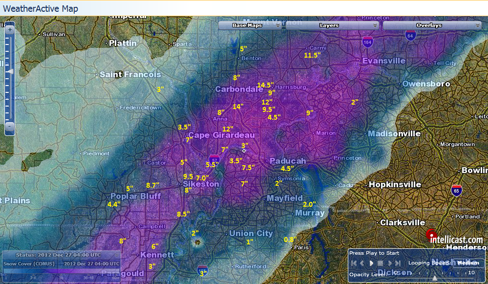
December 26, 2012 Snow Totals - WeatherActive Map from WSI

 
For comparisons sake, here is what our forecast looked like going into the event and pretty close to what we had 3 days out. I can honestly say its about as close as one could get to verifying. Truly a difficult storm but thankfully in the end it lined up pretty well and those who in the path of heaviest snow were prepared.

Comments

Popular posts from this blog

Mid-South Winter Outlook 2023-2024

Getting a general idea of what the upcoming Winter months (December, January and February) will look like for our region can be heavily influenced by El Nino and La Nina episodes. Global and oceanic forecasters have observed El Nino conditions in the central and eastern Pacific Ocean and an EL NINO ADVISORY has been issued. The episode is expected to continue through Spring (March, April and May) in the Northern Hemisphere. Model projections are pointing to a strong, possibly very strong episode occurrence.  (Current Sea Surface Temps warming off S. America) Meteorologists look at monthly data from Dec - Jan - Feb to determine a winter season average, or define that period of time as Meteorological Winter. An average winter in the Local 6 area shows an average temperature of 37 degrees, average precipitation total of 12.18" and average snowfall of 8.4". The National Weather Service in Paducah has historical data that covers 7 of the past strongest El Nino episodes in the past

Planting Zones Heading North

As our global climate changes, so does our planting zones, helping us determine which flowers/shrubs/trees are hardy in specific areas. The Local 6 area has always been split by 2-3 growing zones so placement becomes very important to those in the agricultural community. The image below represents the average over the past 30 years. Climate Central published the following information:  "What kinds of flowers, shrubs and trees you’ll find at your local nursery depends on your climate — how warm it tends to get in summer, and how cold in winter. A plant that’s happy in Wisconsin might be miserable in Alabama, and vice versa. The U.S. Department of Agriculture has formalized these differences into " hardiness zones " — strips of similar climate that run more or less east-to-west (except in the high mountains), where particular plants should do especially well. But as the planet warms under its thickening blanket of greenhouse gases, those zones are shifting northward. Th

Update: Impacts From Tropical Depression Bill

Friday AM Update Heavy rain still appears to be our greatest concern as the remnants of Tropical Storm Bill pass directly over the Local 6 area throughout the day today. A Flash Flood WATCH continues for Southern Illinois, SE Missouri, and the Ohio River counties in Western Kentucky through Saturday. Here is a look at today's forecast concerning rainfall totals from the Weather/Hydrological Prediction Center. In any given area, 2-4 inches of rain will be possible. Low-lying areas are most prone to flash flooding. Showers and storms will increase in coverage and intensity during the day on Friday.  Keep preparedness and awareness in mind as heavy rain moves in. Locate areas of higher ground in the event you need to retreat there. Never drive across flooded roadways. Keep children from playing in flood waters. Water depth and swiftness is difficult to determine. Below is the latest Flash Flooding Potential Briefing from the Paducah National Weather Service.