2012 brought a year of extremes across the Local 6 area and also took with it the precious lives of 8 community members and devastated a river/agricultural industry. Here is a preview & list of events that rank as the Top 6 weather stories of 2012 on WPSD Local 6:
1. Leap Day Tornadoes - Harrisburg EF-4 Tornado:
 I felt my stomach drop the moment I saw the EF4 tornado damage as I pulled into Harrisburg the following day. I knew it was going to be bad and I couldnt imagine going through the terror of waking up in the middle of the night as a powerful tornado raced my way. Daylight brough a scene of devastation to the south side of Harrisburg and disbelief spread across this close-knit town. Eight of their residents lost their lives to the storm.
 News quickly traveled to the national media and hundreds of volunteers converged on the heartbroken town to assist those in need of a lending hand. It didnt take long for the community and local volunteers to rally and clean the debris away. Less than a year later, you can barely tell where the tornado struck. Homes have been either completely cleared or rebuilt and businesses have been restored despite FEMA rejecting thier applications for funding/assistance.

2. Driest Year on Record, Drought of 2012: Wildfires, total crop loss, livestock loss, haulted river traffic, and restricted water use were all a result of one of the driest years on record at the Paducah National Weather Service and much of Western Kentucky. With only 4.95" for the entire Spring season, it became the driest on record beating the old record of 5.66" in 1987. 5.43" of rain was recorded for the Summer season, making it the 4th driest ever. At the end of 2012 the Paducah Area recorded the driest year on record just after recording the wettest year on recrod, 2011.
Alongside the relentless dry weather pattern, the area jumped straight in to Summer with record daytime highs in the 80's as early as March. Read more on the excessive heat in #3 below.
3. Excessive Summer Heat 2012: Unusually warm weather began to become a theme for the year as early as March for the Local 6 area. While record highs in the 80's were being recorded, farmers were planting their fields at a record early time. A bumper crop was anticipated until one of the Nation's worst droughts ended those hope by early summer.
 The ALL-TIME record high temperature of 108 degrees in Paducah was set back in July of 1942...that record was tied in 2012 on June 29th. Just the start of what was a record-breaking warm year. Here are the other impressive stats listed by the Paducah National Weather Service:
Just three days later, another 4-6" of snow dropped on S. IL and SE MO. making for trecherous road conditions as roads refroze during the overnights with lows in the teens.
5. January 22, 2012 Severe Weather Outbreak: A rather large, winter complex of severe thunderstorms developed just west of the area and moved aggressively across the Local 6 area bringing with it destructive winds and a handful of tornadoes during the dark hours following sunset.
The Murray State Racers suspended play during one of their home basketball games to take cover as a tornado warned storm moved across the south side of town. EF1 damage was confirmed in Hazel, KY as it tracked 5.6 miles. Enfield, IL took a glancing hit and EF2 tornado damage/track was surveyed for 18 miles just outside of town.
6. March 2, 2012 Severe Weather Outbreak: For the first time in my career, I left the weather wall with radar running and joined all other WPSD employees taking cover as a tornado warned storm and golf ball size hail hammered the station. Just 3 days earlier Harrisburg, IL was struck by an EF4 tornado and another deadly outbreak was already underway. In the end 2 tornadoes were confirmed in the Local 6 area but many communities suffered moderate wind damage along with large hail. The same storm sytem went on to produce deadly tornadoes in West Liberty, KY, and Henryville, IN.

 |
| Graphic Produced by WPSD Meteorologist Kyle Mounce |
1. Leap Day Tornadoes - Harrisburg EF-4 Tornado:
I felt my stomach drop the moment I saw the EF4 tornado damage as I pulled into Harrisburg the following day. I knew it was going to be bad and I couldnt imagine going through the terror of waking up in the middle of the night as a powerful tornado raced my way. Daylight brough a scene of devastation to the south side of Harrisburg and disbelief spread across this close-knit town. Eight of their residents lost their lives to the storm. News quickly traveled to the national media and hundreds of volunteers converged on the heartbroken town to assist those in need of a lending hand. It didnt take long for the community and local volunteers to rally and clean the debris away. Less than a year later, you can barely tell where the tornado struck. Homes have been either completely cleared or rebuilt and businesses have been restored despite FEMA rejecting thier applications for funding/assistance.
The same tornado that ripped through Harrisburg went on to produce damage to the NW in Ridgeway, IL. One of the town's historic churches was left in rubble as the sun rose a short time later.
The Harrisburg/Ridgeway tornado was not the only tornado to strike during the Leap Day outbreak. A total of 11 tornadoes struck Southern Illinois, Southeast Missouri, and Western Kentucky. This included one tornado that struck Ballard County at 5AM leaving behind EF2 damage and 4 injuries. Little did we know that just a few days later, we'd be preparing for another outbreak of severe weather on March 2. This event also ranks...see below for more.
The video to the right is a CNN interview with Harrisburg Mayor Eric Gregg and his quick response to assist his community members.
The video to the right is a CNN interview with Harrisburg Mayor Eric Gregg and his quick response to assist his community members.
 |
| Wildfire in Land Between the Lakes, Kentucky just south of Grand Rivers. |
3. Excessive Summer Heat 2012: Unusually warm weather began to become a theme for the year as early as March for the Local 6 area. While record highs in the 80's were being recorded, farmers were planting their fields at a record early time. A bumper crop was anticipated until one of the Nation's worst droughts ended those hope by early summer.
 The ALL-TIME record high temperature of 108 degrees in Paducah was set back in July of 1942...that record was tied in 2012 on June 29th. Just the start of what was a record-breaking warm year. Here are the other impressive stats listed by the Paducah National Weather Service:
- June 27: Record low tied - 54 degrees (Last occurred in 2004)
- June 28: Record high tied - 105 degrees (Last occurred in 1952)
- June 29: Record high broken - 108 degrees (Old record 105 degrees occurred in 1952)
- June 30: Record high tied - 106 degrees (Last occurred in 1952)
- July 1: Record high broken - 105 degrees (Old record 100 degrees occurred in 1941)
- July 2: Record high broken - 101 degrees (Old record 100 degrees occurred in 1941)
- July 3: NO RECORDS TIED/BROKEN
- July 4: Record high broken - 101 degrees (Old record 97 degrees occurred in 1954)
- July 5: Record high broken - 105 degrees (Old record 99 degrees occurred in 1980)
- July 6: Record high broken - 107 degrees (Old record 101 degrees occurred in 1939)
- July 7: Record high broken - 104 degrees (Old record 98 degrees occurred in 1988)
- Month of June: Highest Max Temp - 108 deg. on June 29 2012 (Old Record 106 deg. on June 30, 1952)
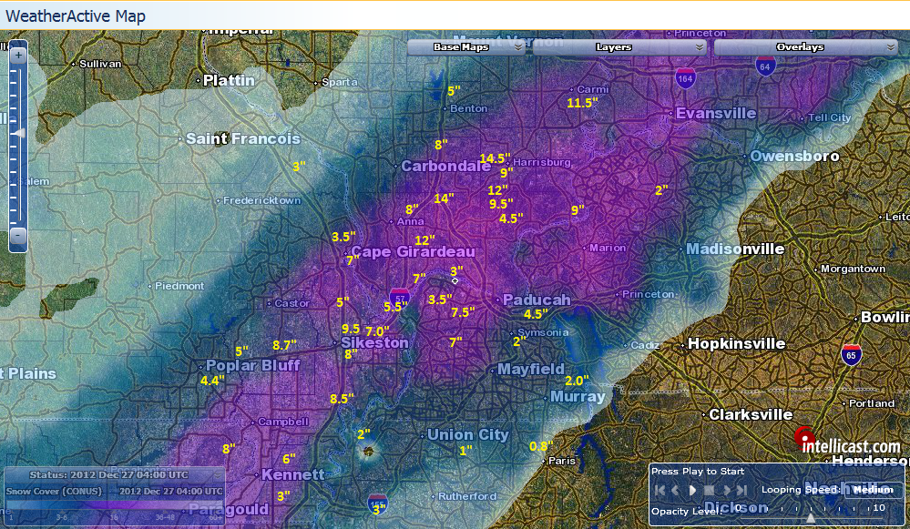 |
| December 25-26th Snowfall Totals - Number totals provided by viewers. |
5. January 22, 2012 Severe Weather Outbreak: A rather large, winter complex of severe thunderstorms developed just west of the area and moved aggressively across the Local 6 area bringing with it destructive winds and a handful of tornadoes during the dark hours following sunset.
 |
| Photo per NWS Paducah - Hazel, KY |
6. March 2, 2012 Severe Weather Outbreak: For the first time in my career, I left the weather wall with radar running and joined all other WPSD employees taking cover as a tornado warned storm and golf ball size hail hammered the station. Just 3 days earlier Harrisburg, IL was struck by an EF4 tornado and another deadly outbreak was already underway. In the end 2 tornadoes were confirmed in the Local 6 area but many communities suffered moderate wind damage along with large hail. The same storm sytem went on to produce deadly tornadoes in West Liberty, KY, and Henryville, IN.

Comments
Post a Comment