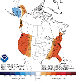
Mid-June Temp/Precip Outlook


Thanks to cloud cover and a persistent trough (dip in the jet stream) over the Eastern US, the start to June has been anything BUT summer-like and rather cool. After day 3, temperatures returned to near normal, and compact storm complexes have begun their annual dive south toward our area. Over the next two weeks it appears that a fairly zonal (a lack of big pattern swings) will set up across the Lower 48. This is why both maps below show "near normal" conditions in their outlooks for Mid-June. So what is "normal" for the Paducah area for Mid-June? From the 12th through the 18th we typically see temperatures average 86 for highs and 65 for lows. Average precipitation amounts to 0.91" at the Paducah Barkley (PAH) location. 


So far the influence of El Nino has been fairly weak which was expected as El Nino is still in its weakest stage. On a larger scale, its very definition has brought warmer waters off the western coast of South America, which has helped to sustain and even strengthen Hurricane Blanca near the Baja. This may actually enhance a monsoon-like season for the Desert SW and eventually spread a little moisture our way by mid-June.  According to the Climate Prediction Center, "there is an approximately 90% chance that El Niño conditions will continue through Northern Hemisphere summer 2015, and a greater than 80% chance it will last through 2015." 

Until El Nino conditions strengthen more, the Local 6 area will probably see little affect. The overall slightly cooler or average conditions will remain and a stream of moisture to bring occasional showers and storms appears likely for the summer season. The risk for widespread drought is currently low except where typical for late July/August.


Comments

Popular posts from this blog

Mid-South Winter Outlook 2023-2024

Getting a general idea of what the upcoming Winter months (December, January and February) will look like for our region can be heavily influenced by El Nino and La Nina episodes. Global and oceanic forecasters have observed El Nino conditions in the central and eastern Pacific Ocean and an EL NINO ADVISORY has been issued. The episode is expected to continue through Spring (March, April and May) in the Northern Hemisphere. Model projections are pointing to a strong, possibly very strong episode occurrence.  (Current Sea Surface Temps warming off S. America) Meteorologists look at monthly data from Dec - Jan - Feb to determine a winter season average, or define that period of time as Meteorological Winter. An average winter in the Local 6 area shows an average temperature of 37 degrees, average precipitation total of 12.18" and average snowfall of 8.4". The National Weather Service in Paducah has historical data that covers 7 of the past strongest El Nino episodes in the past

Planting Zones Heading North

As our global climate changes, so does our planting zones, helping us determine which flowers/shrubs/trees are hardy in specific areas. The Local 6 area has always been split by 2-3 growing zones so placement becomes very important to those in the agricultural community. The image below represents the average over the past 30 years. Climate Central published the following information:  "What kinds of flowers, shrubs and trees you’ll find at your local nursery depends on your climate — how warm it tends to get in summer, and how cold in winter. A plant that’s happy in Wisconsin might be miserable in Alabama, and vice versa. The U.S. Department of Agriculture has formalized these differences into " hardiness zones " — strips of similar climate that run more or less east-to-west (except in the high mountains), where particular plants should do especially well. But as the planet warms under its thickening blanket of greenhouse gases, those zones are shifting northward. Th

Update: Impacts From Tropical Depression Bill

Friday AM Update Heavy rain still appears to be our greatest concern as the remnants of Tropical Storm Bill pass directly over the Local 6 area throughout the day today. A Flash Flood WATCH continues for Southern Illinois, SE Missouri, and the Ohio River counties in Western Kentucky through Saturday. Here is a look at today's forecast concerning rainfall totals from the Weather/Hydrological Prediction Center. In any given area, 2-4 inches of rain will be possible. Low-lying areas are most prone to flash flooding. Showers and storms will increase in coverage and intensity during the day on Friday.  Keep preparedness and awareness in mind as heavy rain moves in. Locate areas of higher ground in the event you need to retreat there. Never drive across flooded roadways. Keep children from playing in flood waters. Water depth and swiftness is difficult to determine. Below is the latest Flash Flooding Potential Briefing from the Paducah National Weather Service.