 The Climate Prediction Center has entered into El Nino Watch with a 60% chance of episode development during the Fall (Sep-Nov) and a 70% chance of episode development by Winter (Dec-Feb). Meteorologists monitor the status of El Nino and La Nina because it can have a direct impact on the large-scale weather pattern over the United States, especially during the Summer and Winter months.
The following two graphics show how temperatures and precipitation are typically impacted by an El Nino episode during the winter months. Winters tend to be warmer than normal and precipitation stays fairly average. The two maps compare previous winter El Nino episodes to the long-term average from 1950-2007.
 |
| NOAA/NCDC - Click to enlarge |
The National Weather Service in Paducah has historical data that covers 6 of the past strongest El Nino episodes in the past 75 years (according to current forecast trends).
The similar El Nino episodes include the winters of 1957-1958, 1965-1966, 1972-1973, 1982-1983, 1991-1992 and 1997-1998. In each episode, temperatures averaged close to or above normal. In these 6 cases, the stronger the El Nino episode, the warmer the winter averaged. 1997-1998 was a record strong episode and temperatures averaged about 4 degrees warmer for the season. For the entire central region, (IL, IN, OH, WV, KY, TN, MO) it still holds the record for 2nd warmest winter.
 |
| Credit: Paducah NWS |
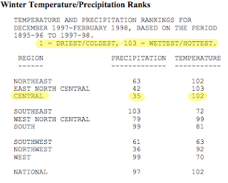
Moving on to precipitation. Most of the cases averaged close to normal for the season with the exception of winter 1982-1983. I believe this to be an exceptional case since on one single day, (Dec 3) a record 4.65" of rain was recorded. If we exclude that one single day, 1982-1983 would also calculate close to average. In the central region precipitation ranked 35th driest during the record El Nino episode of 1997-1998.
It is a completely different scenario for snow totals. As the El Nino events in this post gained strength, the average snowfall dropped significantly. Winter 1957-1958 was the only season that came close to the average with 7.9".
 |
| (NCDC - El Nino of 1997-1998) |
Simply put....warmer El Nino winters tend to bring less snow to the Local 6 area but do not leave us short-changed in precipitation. If the predicted El Nino episode ahead materializes as predicted by NOAA, we could be looking at a warmer winter than last year and continue with our slightly wetter weather pattern.
As a personal forecaster's disclaimer.....remember it only takes ONE snow event to make a big impact. In most of the winter cases from the past, we had quite a few TRACE snow days, just not accumulating. Use this information as guidance and for planning.
What is El Nino or La Nina?
The way scientists identify a developing episode of El Nino or La Nina is by monitoring the warming/cooling waters off the coast of South America. When the westerly winds over the Pacific weaken, it allows for the oceanic circulation to bring cooler waters to the surface near South America then spread westward into the central Pacific. This phenomenon is known as La Nina. In opposition, the strengthening of westerly winds can build very warm water further east toward the coast of South America. This phenomenon is known as El Nino. The El Nino and La Nina related patterns of tropical rainfall cause changes in the weather patterns around the globe.


Comments
Capsa Susun
BandarQ
Poker Online
Domino Online
AduQ
Bandar66
Sakong
Bandar Poker
Sabung Ayam
Roullet online
Baccarat Online
Dadu Koplo
Slot
Agen Domino99
Post a Comment