......during National Severe Weather Preparedness Week!
FEMA and NOAA partnered to designate March 3-9, 2013, as National Severe Weather Preparedness Week, and is calling upon all Americans to Be a Force of Nature.
I'm a firm believer and am committed to Being a Force of Nature and pledge to do so by: knowing our risk, taking action, and being an example for our families and community by sharing the steps we took to be prepared. Because we live in an area prone to tornadoes, flash floods, severe thunderstorms, and high winds the last year's winter EF4 Harrisburg tornado reminded us that this weather can strike anywhere and at any time.
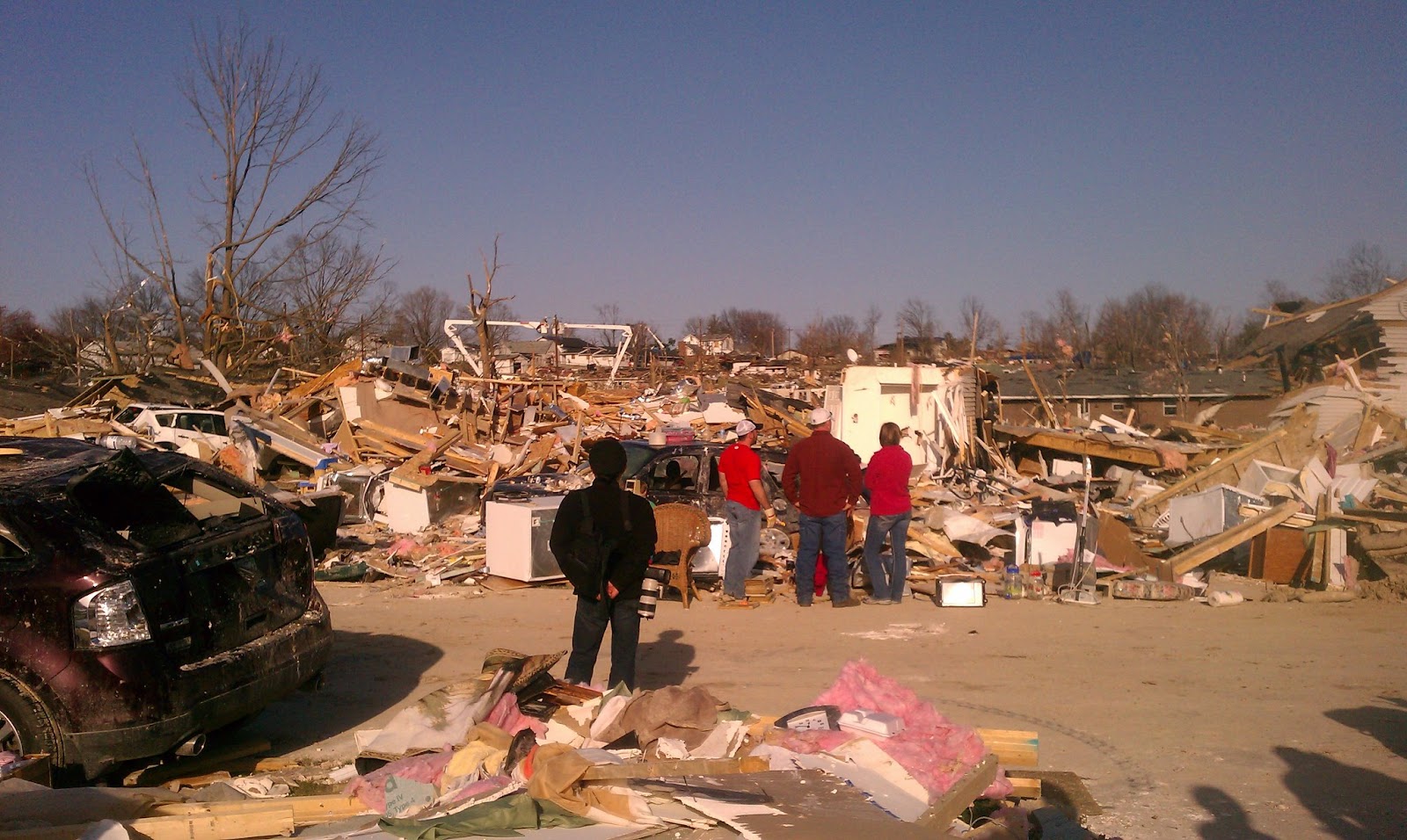
 |
| Harrisburg, IL Leap Day 2012 - EF4 Damage |
Just this past year, there were more than 450 weather-related fatalities and nearly 2,600 injuries. Each time severe weather threatens we hear stories of ordinary Americans who do the extraordinary to save loved ones – a mother protecting her children by shielding them from flying debris, a homeowner opening up his storm shelter to neighbors, neighbors helping a senior in a wheelchair get to a safe shelter, individuals ensuring friends are aware of the current watch or warning in their area.
 |
| Harrisburg, IL Leap Day 2012 - EF4 Damage |
Building a Weather-Ready Nation requires that every individual and community take action because severe weather knows no boundaries and affects us all. Be a Force of Nature by making a public pledge to be prepared at ready.gov/severe-weather.
What can you do to Prepare?
Knowing your risk, taking action and being an example by sharing your knowledge and actions through your social network are just a few steps you can take to be better prepared and assist in saving lives.
Know Your Risk:
The first step to becoming weather-ready is to understand the type of hazardous weather that can affect where you live and work, and how the weather could impact you and your family. Every state in the United States has experienced tornadoes and severe weather, so everyone is exposed to some degree of risk. Severe storms, tornadoes, flooding, and . Check with WPSD Local 6, The Weather Authority forecast regularly and visit ready.gov/severe-weather to learn more about how to be better prepared and how you can protect your family during emergencies.
Pledge and Take Action:
Be Force of Nature by taking the Pledge to Prepare at ready.gov/severe-weather. When you pledge to prepare, you will take the first step to making sure that you and your family are prepared for severe weather. This includes filling out your family communications plan that you can email to yourself, putting an emergency kit together, keeping important papers and valuables in a safe place, and getting involved.
Obtain a NOAA Weather Radio, and check to see if your cell phone is equipped to receive Wireless Emergency Alerts and sign up for localized alerts from emergency management officials. Beginning March 1st, Local 6 area Walgreen's stores will be offering Midland Weather Radios for home and travel at a discounted price.
Be an Example:
Once you have taken action and pledged to Be a Force of Nature, share your story with your family and friends. Create a video and post on a video sharing site; post your story on Facebook, LinkedIn, Twitter, comment on a blog, or share through any other social media site. Technology today makes it easier than ever to be a good example and share the steps you took to help us achieve the vision of a Weather-Ready Nation.
Join us today and pledge to prepare for the severe weather in our area.
Information on the different types of severe weather such as tornadoes, severe thunderstorms and flooding is available at www.weather.gov and ready.gov/severe-weather or the Spanish-language web site www.listo.gov.
Information provided by NOAA and Weather Ready Nation
Comments
Post a Comment