Wednesday September 9, 2015 Update:
 |
| Created by Jennifer Rukavina via NOAA/ESRL Data |
 |
| Created by Jennifer Rukavina via NOAA/ESRL Data |
August 21, 2015 Original Post
Forecasting into the season ahead is most accurate when looking to similar weather patterns of the past. As you have probably seen in the news El Nino is expected to strengthen into the upcoming fall and winter. I've done a little digging into the historical record to find out how we have fared during similar El Nino episodes. Here is what I was able to find...
 Meteorologists look at monthly data from Dec - Jan - Feb to determine a winter season average, or define that period of time as Meteorological Winter. A winter in the Local 6 area shows an average temperature of 37 degrees, average precipitation total of 12.18" and average snowfall of 8.4".
The National Weather Service in Paducah has historical data that covers 5 of the past strongest or similar El Nino episodes in the past 75 years (according to current forecast trends).
 |
| (Click to Enlarge - Credit Jennifer Rukavina & Paducah National Weather Service climate records) |
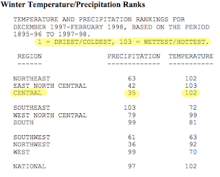
Moving on to precipitation. Most of the cases averaged close to normal for the season with the exception of winter 1982-1983. I believe this to be an exceptional case since on one single day, (Dec 3) a record 4.65" of rain was recorded. If we exclude that one single day, 1982-1983 would also calculate close to average. In the central region precipitation ranked 35th driest during the record El Nino episode of 1997-1998.
It is a completely different scenario for snow totals. As the El Nino events in this post gained strength, the average snowfall dropped significantly. Winter 1965-1966 was the only season that came close to the average with 5".
 |
| (NCDC - El Nino of 1997-1998) |
Simply put....warmer El Nino winters tend to bring less snow to the Local 6 area but do not leave us short-changed in precipitation. If the predicted El Nino episode ahead materializes as predicted by NOAA, we could be looking at a much warmer winter than last year and continue strong with our wet weather pattern.
As a personal forecaster's disclaimer.....remember it only takes ONE snow event to make a big impact. In most of the winter cases from the past, we had quite a few TRACE snow days, just not accumulating. Use this information as guidance and for planning but we all know weather/climate in the Mid-South is anything but certain. :)
Comments
Post a Comment