TUESDAY MIDDAY UPDATE:

Storms still follow the timeline of late Wednesday afternoon into the evening hours before midnight. The ENHANCED RISK of storms has been adjusted a bit further north from yesterday's outlook which is what we were expecting with the greater risk of tornadoes over MO/IL and a continued threat for damaging winds in TN/KY. Here is a look at the latest as of this morning.
 The graphic below explains the different risk categories. Safety and preparedness information still exists further down in this post. A larger update will be available here this evening.
MONDAY MORNING UPDATE:
 Thoughts discussed yesterday of seeing our region outlined in an enhanced or moderate risk for severe weather have materialized this morning with the newest forecast from the Storm Prediction Center. Storms will develop during the afternoon into the evening on Wednesday as a potent storm system barrels through the Midwest and Midsouth. Damaging winds and tornadoes will be possible. Here is the latest map:
Remember, Fall severe weather is particularly dangerous for a couple of reasons:
1. Storms tend to be driven by strong winds and move at faster speeds. This can give us less time to react and take action when warnings are issued.
2. Storms can continue into the dark hours after sunset making it almost impossible to see storms coming and can occur when many of us are sleeping. Weather radios and text alerts are a must!
In the following video Trent Okerson shows you what to do when a tornado warning is issued and how you can practice your tornado plan with your family:
 WPSD Local 6: Your news, weather, and sports authority
SUNDAY AFTERNOON UPDATE:
Last week was a teaser for our fall severe weather season and thankfully a few limbs and heavy downpours was all we endured. This Wednesday a much potent storm system is headed our way and reminds us to brush up on our severe weather preparedness.
Here is the latest outlook from the Storm Prediction Center for Wednesday:
 Primary threats will include large hail, damaging winds, and even tornadoes. It is still a few days away but the computer models are hinting at an outbreak of severe weather. That simply means the threat will be higher and more widespread across our area. I anticipate the Storm Prediction Center putting the Local 6 area in an Enhanced or Moderate Risk early this week to prepare the public for this severe weather threat.
 The graphic below explains the different risk categories. Safety and preparedness information still exists further down in this post. A larger update will be available here this evening.
MONDAY MORNING UPDATE:
 Thoughts discussed yesterday of seeing our region outlined in an enhanced or moderate risk for severe weather have materialized this morning with the newest forecast from the Storm Prediction Center. Storms will develop during the afternoon into the evening on Wednesday as a potent storm system barrels through the Midwest and Midsouth. Damaging winds and tornadoes will be possible. Here is the latest map:
Remember, Fall severe weather is particularly dangerous for a couple of reasons:
1. Storms tend to be driven by strong winds and move at faster speeds. This can give us less time to react and take action when warnings are issued.
2. Storms can continue into the dark hours after sunset making it almost impossible to see storms coming and can occur when many of us are sleeping. Weather radios and text alerts are a must!
In the following video Trent Okerson shows you what to do when a tornado warning is issued and how you can practice your tornado plan with your family:
SUNDAY AFTERNOON UPDATE:
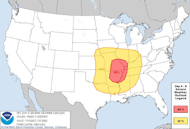
Last week was a teaser for our fall severe weather season and thankfully a few limbs and heavy downpours was all we endured. This Wednesday a much potent storm system is headed our way and reminds us to brush up on our severe weather preparedness.
Here is the latest outlook from the Storm Prediction Center for Wednesday:

 Primary threats will include large hail, damaging winds, and even tornadoes. It is still a few days away but the computer models are hinting at an outbreak of severe weather. That simply means the threat will be higher and more widespread across our area. I anticipate the Storm Prediction Center putting the Local 6 area in an Enhanced or Moderate Risk early this week to prepare the public for this severe weather threat.
Starting tonight on Local 6 at 5 and 10pm, Trent will be looking at this system more in depth. Don't forget to review our new Preparedness Playlist with short videos showing you how to prepare and protect your family when severe weather threatens. Click here for a link to watch them. Bookmark this page and look for daily updates this week as we get closer to the event.
Comments
Post a Comment