A look at snow totals as of 2:30PM for the Local 6 area.


 |
| Storm reports and map provided by the National Weather Service |
SUNDAY IS A WEATHER AUTHORITY ALERT DAY
SATURDAY AFTERNOON UPDATE:

 A WINTER WEATHER ADVISORY will go into effect starting at 3AM Sunday morning running until 3AM Monday morning for accumulating snow and hazardous driving conditions.
Expected snow totals have been raised just a bit since last night.
To the right is a look at what each computer model is projecting for snow totals in the Paducah area, ranging from 1-4" by Sunday evening. I detailed each state further down the page so you can see what to expect where you live compared to everyone else in the Local 6 area.
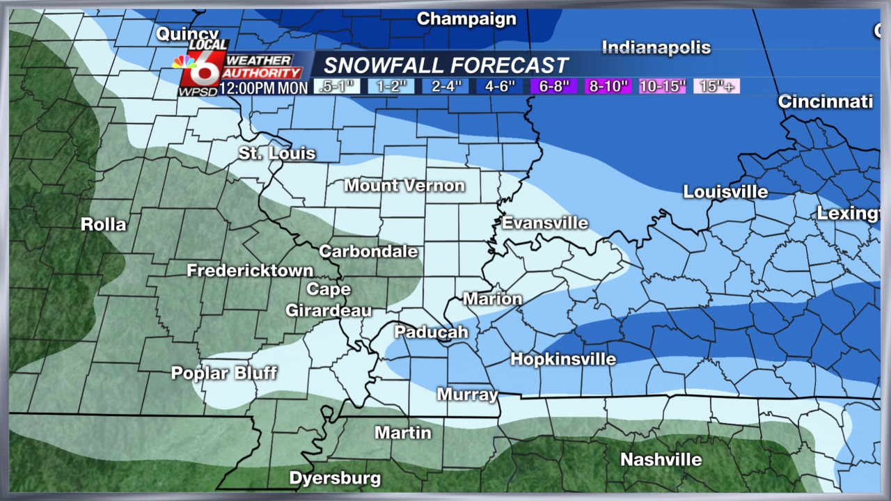
Also, below is the latest map of the Local 6 area and snowfall forecast. Some of the snowfall forecast totals below may also include sleet accumulation, especially across KY/MO. Freezing rain may also cause some slick conditions on roads left untreated. To see the breakdown on who will see what, check the state outlooks below.


FRIDAY PM UPDATE:
 A wintry mix of precipitation is looking more likely to overspread the Local 6 area starting early Sunday morning. A mix of snow, sleet, and freezing rain will be possible by daybreak across Missouri and Western Illinois. A warmer layer of air aloft will begin to transition this wintry mix over to sleet and rain by evening for everyone and mild temperatures will settle in for much of next week.
Here's an idea of the timeline with geographical areas:
- Missouri: A mix of snow, sleet, and freezing rain will make for an icy mix to start Sunday morning. There may be a period of time where we could see light accumulation of sleet/snow through late morning, generally less than an inch. The further north toward Cape Girardeau, the better chance you have to seeing snow. The Bootheel from New Madrid and south is likely to see more of the icy mix. Precipitation will likely move out by early evening.
- Kentucky: There should be just enough cold air to see mainly snow with occasional sleet and freezing rain mixing in close to the TN state line. Snow accumulations will be most likely across the Purchase and Pennyrile with higher totals east of The Lakes area (possibly 4"). The Paducah area looks to see 1-3" of snow with some sleet possible. (See map above)
- Tennessee: An icy mix is most likely across NW Tennessee to start the day Sunday as a warmer layer of air wedges into the mid-levels of the atmosphere. This would likely lead to freezing rain and sleet, possible a little snow mixing in closer to the KY state line. Untreated roads will become slick until most of the precipitation switches over to rain by afternoon.
- Illinois: Look for light to moderate snow showers starting early in Western Illinois then overspreading all of Southern Illinois by late morning. 1-2" of snow will be possible and more likely closer to the Ohio/Wabash Rivers.
 The graphic to the left shows the various forecast models we analyze when forecasting snow totals. They are signaling a 2-3" range for the Paducah area as of Friday night. I will post additional updates throughout the weekend so you can see the changes that may come as the storm develops to our southwest.
Comments
Post a Comment